I recently revised my article "How To: Lightning Photography". Some minor changes have been made and I go more in depth with the camera settings. The storm season is upon us. If you are willing to try to photograph lightning this might help you.
http://www.bdjphoto.com/pages/how_to_lightning_photography.htm
On a different note, it looks like I will be chasing on Friday. The forecast models continue to show what appears to be the best "chase day" scenario for Friday, April 2nd. Its still a little far off, so I have not narrowed down a target area yet. Check back for updates.
As always, Thank you for the support.
-Ben

Sunday, March 28, 2010
Saturday, March 20, 2010
03/19/10, OK: The First REAL Chase of 2010!...
 The SPC Severe weather outlook. A "See Text" usually means a less than 5% probability of severe weather.
A strong storm system was going to make its way through our forecast area and bring with it a chance for thunderstorms. The NWS was calling for a winter storm to move through the next day. A potent cold front was the trigger for thunderstorm development. The SPC (Storm Prediction Center) was not saying much as far as a severe weather episode, but despite MUCAPE values of 500 J/kg, and weak moisture return 50 DPs. There was still an isolated supercell or two. I left work around 6:00pm and headed for Waurika, OK where some cumulus towers were beginning to build. Its a good thing I went because I intercepted a photogenic supercell just outside of Comanche, OK. The velocity scans only showed a broad area of rotation, however I was able to photograph a nice mesocyclone and rotating wall cloud. I saw a few funnels while driving and unfortunately was unable to photograph them.
Thanks for the support!
-Ben

Radar at 6:15pm leaving Wichita Falls and heading north towards Waurika. You can already see some cells popping up on the Red River. The northern cell is the one I end up chasing.

On my way to the target area, you can see the storm start to develop to my NW.

I lost my GPS signal so I drew in my approximate location (yellow circle). On radar the storm doesn't look to impressive.

The storm starts to look a little better on radar and I can see a decent base now.

A base! This storm was starting to look better after all.

Still a little far off, but its nice to see some noticeable structure. You can see the main updraft base over the tree and a beaver tail-like inflow band coming in from the right.

Hmm...Is that a lowering in the base? Scud? Lets take a closer look.

Yep, that is definitely a lowering with rising motion.

A quick radar scan. Does that storm look like its trying to hook? I do believe so.

Velocity scans show an area of weak broad rotation.

I don't think this qualifies as a wall cloud, but it is very close. Starting to see a little structure now.

This storm is trying to do something, but it just can't seem to get it together.

I had to find a spot to pull over to photograph this. There is the main base/mesocyclone around the center of the frame.

The old mesocyclone occludes and is cut off from the unstable air. And a new one forms (lower left).

Structure! The new meso starts to rotate rapidly. Now a rotating wall cloud is visible.

Beautiful! Great structure and wall cloud. The light is fading pretty quickly and I don't have much time left.

This storm starts to occlude (again) and the wall cloud tightens up and forms a very convincing funnel. Which I am unable to capture because I was driving.

Cold front catches up and all the storms start to form into a line.

This is the last of the structure. Mesocyclone and beaver tail. After I take this photo the storm turns into a squall line.
Not to shabby for my first chase of 2010. Special thanks to Jason Brock for nowcasting.
Tuesday, March 16, 2010
Field Trip to Fredrick, OK and Hackberry Flats...
 Members of the Red River Photography Club photographing an old shed outside of Fredrick, OK.
This past Saturday I went with the Red River Photography Club to Hackberry Flats to photograph migrating birds. We left around 7:45 am and did not return until 5:30 that evening. Other than nearly getting lost, it was a great trip. I can't wait for the next field trip
Here are some of the captures.
Thanks.
-Ben

A pair of Red Wing Blackbirds.

Lesser Yellow Legs searching the ravine for food.

Incoming Swainson's Hawk!

He banked into some better light and I was able to capture him flying in front of us.

A Vesper Sparrow flies into the grass right in front of us. *Thanks to the Hackberry Flats Information Center staff for help on the identification*

The very cooperative Vesper Sparrow decides to hang around longer and pose for us.
 After this photo this little sparrow decided we had photographed him enough.

Great Blue Heron.
After the Hackberry Flats trip we went into Fredrick, OK for lunch and on our way back we stopped at a few old houses to photograph them.

#1: Rusty blades from a field plow resting in the front yard of an abandoned home.


#2: An old barn sitting in an empty field

Close up of the shed's rust. Nice texture.

This is looking through a hole in the wall. The light hit this just right to create these great shadows. A wider shot of the shed and a small weed that popped out of the field.
 #3: Another old structure. This was a barn at the Primitive Camping area in the Hackberry Flats Wildlife Management Area.


I love the colors of the rust on these nails. This shot actually looks a little spooky
 This nail has a lot of texture and the curves of the nail is what inspired me to take this shot.
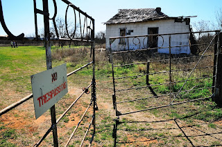
#4: This was outside of US 70. Even though the sign says "No Trespassing" it didn't stop the Red River Photography Club.


After the old barn/houses shoot we drove back home, but there was one other place we had to stop.

What? Camels in Western North, TX? Yep, there is a small group outside on US 287 S. And of course we had to stop and take some photos.
A member of the RRPC gets a nice close up of a very friendly camel.

One of the camels came very close to me and I captured this with my 17-50mm lens.

Now that is a sneer!

Friday, March 12, 2010
03/08/10 Local Chase...
 A severe thunderstorm bows out as it reaches Wichita Co.
With the official start of the chase season just around the corner, I am getting a little anxious and impatient. But luckily I was able to get my storm chasing fix. A strong storm system took shape over AZ and brought storms/precipitation to OK and Northern, TX. We had great wind/shear profiles and decent moisture return, but we lacked instability. Clouds covered the sky through most of the morning. The models were only forecasting CAPE values of 500-750 J/kg. However, a small narrow strip of sunshine raised the surface instability value up to 1200 J/kg. Now that is more like it! A line of storms began to form along this axis, stretching from Vernon, TX down to Abeline, TX. These storms moved into our area and the moment I got off for lunch I went out to chase. I ended up chasing a bow structure from Wichita Falls to Henrietta. I would have kept on going, but I had to return to work. It was nice to be out chasing again. I can't wait for this season! (Looks like I need another fix!)
Thanks.
-Ben
 The SPC day 1 Thunderstorm Outlook. "SLGT" indicates a slight risk of severe thunderstorms.
Mesoscale Discussion issued for our area. *Note the instability axis in the west*

Storms begin to form and start to move to the NE at 45mph.

Bow echo moving towards Metro Photo (My GPS signal is the dot)

The chase is on! Looking outside of Metro Photo this is the view of the gustfront. Look at that nice dark core in the background.

Ominous Enough for you? Right after this photo I got soaked in sheets of heavy rain. This storm is moving so fast that I can only chase the tail end of the gustfront.

I catch up on my way to Henrietta and get caught in the core again. This time it dropped heavier rain and a few stones of pea sized hail. The winds were also pretty strong with a max gust of 48mph.

Unfortunately, I had return back to work but before I walked in I was greeted with this scene of mammatus clouds.
If only I had the day off. Later on that day a low topped supercell formed over Western OK and dropped and EF-2 tornado in Hammon, OK. Looking forward to the new season.
Subscribe to:
Posts (Atom)
About Me

- shutterbug2007
- I am 25 years old and I have been a photographer for 11 years now. I love nothing more than taking my camera out on a photo shoot with me. I mainly focus on nature photography.That is where my passion is. I love looking at all of God's wonderful creations and capturing them in the photographic medium. I have won awards and have received special recognition for my photography. It is my calling and my passion!